


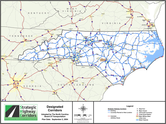
North Carolina
| Trillion Dollar Highway Plans = Multiple Bypass Surgery a state by state list |
|
| High Priority Corridors specified by Congress in 1991, 1995, 1998, 2005, 2012 |
|
| NAFTA Superhighways | |
| Corridors of the Future | |
| J. Edgar Hoover Parkway: transportation surveillance, mileage taxes, RFID & video tolling |
|
| Paving Appalachia:
Corridor A to X in AL, GA, MD, MS, NC, NY, OH, PA, SC, TN, VA, WV |
|
| Alabama | Nebraska |
| Alaska | Nevada |
| Arizona | New Hampshire |
| Arkansas | New Jersey |
| California | New Mexico |
| Colorado | New York |
| Connecticut | North Carolina |
| Delaware | North Dakota |
| Florida | Ohio |
| Georgia | Oklahoma |
| Hawai'i | Oregon |
| Idaho | Pennsylvania |
| Illinois | Rhode Island |
| Indiana | South Carolina |
| Iowa | South Dakota |
| Kansas | Tennessee |
| Kentucky | Texas |
| Louisiana | Utah |
| Maine | Vermont |
| Maryland | Virginia |
| Massachusetts | Washington |
| Michigan | Washington, D.C. |
| Minnesota | West Virginia |
| Mississippi | Wisconsin |
| Missouri | Wyoming |
| Montana | |
A candidate for the most road crazy state, certainly a top contender for the title. The State's goal is to have a four lane (or more) divided highway within ten miles of anywhere in North Carolina, they are close to achieving this. North Carolina may also be the most road dense State that did not have a major freeway fight that prevented roads, at least as far as I have been able to research. Virginia and California and a few other contenders for "most paved" have had several major citizen efforts that blocked some road proposals.
High Priority Corridor 5: I-73/74 North-South Corridor
I-73, I-74, routes 27, 127, 223, 23, 52, 220, 501
In the States of North Carolina and South Carolina, the Corridor shall generally follow:
- in the case of I-73--
- United States Route 220 from the Virginia State line to State Route 68 in the vicinity of Greensboro;
- State Route 68 to I-40;
- I-40 to United States Route 220 in Greensboro;
- United States Route 220 to United States Route 1 near Rockingham;
- United States Route 1 to the South Carolina State line; and
- South Carolina State line to the Myrtle Beach Conway region to Georgetown, South Carolina, including a connection to Andrews following the route 41 corridor and to Camden following the U.S. Route 521 corridor; and
- in the case of I-74--
- I-77 from Bluefield, West Virginia, to the junction of I-77 and the United States Route 52 connector in Surry County, North Carolina;
- the I-77/United States Route 52 connector to United States Route 52 south of Mount Airy, North Carolina;
- United States Route 52 to United States Route 311 in Winston-Salem, North Carolina;
- United States Route 311 to United States Route 220 in the vicinity of Randleman, North Carolina;
- United States Route 220 to United States Route 74 near Rockingham;
- United States Route 74 to United States Route 76 near Whiteville;
- United States Route 74/76 to the South Carolina State line in Brunswick County; and
- South Carolina State line to the Myrtle Beach Conway region to Georgetown, South Carolina.
www.ncdot.gov/projects/I74feasibility/
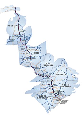
Many transportation needs can be satisfied through this study's potential alignment of I-74, including the completion of a vital section of the proposed I-74 interstate from Michigan to South Carolina ...
The regional goal of the Governor's plan is to provide an economic boost for the area with this new interstate (I-74) in conjunction with other projects such as interstate I-20 and the extension of the Wilmington Outer Loop. ...
The study corridor begins west of the US 74-76 interchange with US 701 in Whiteville and continues along existing US 74-76 to 1.25 miles west of Bolton. It proceeds southward on new location to the Columbus/Brunswick county line. The study corridor travels southward alongside existing NC 211 from the county line to US 17 in Supply. The I-74 corridor then turns southwest and travels along the US 17 corridor, utilizing the Shallotte Bypass, and finally terminating at the South Carolina state line. The total length of the project varies from 63.3 miles to 65.5 miles, depending on which alignments are selected.
I-74 study in southern North Carolina:

High Priority Corridor 17: US 29
US 29, I-785 (future)
Greensboro, NC to Washington, DC
High Priority Corridor 40: the Greensboro Corridor
The Greensboro Corridor from Danville, Virginia, to Greensboro, North Carolina, along United States Route 29. [seems to be a duplicate of Corridor 17]
Charlotte Beltway is mostly finished (I-485)
numerous other bypasses and new interstates recently finished elsewhere in North Carolina, especially in central part of the state.
I-73 and I-74 have had major segments built in recent years in central NC.
I-795 to Goldsboro recently built
I-40 and I-77 interchange expansion
www.ncdot.gov/projects/i40i77Improvements/
$89 million expansion includes a "new multi-level interchange," widening I-40 and I-77, and collector distributor lanes (local / express lanes). There are countless similar projects all over the country.
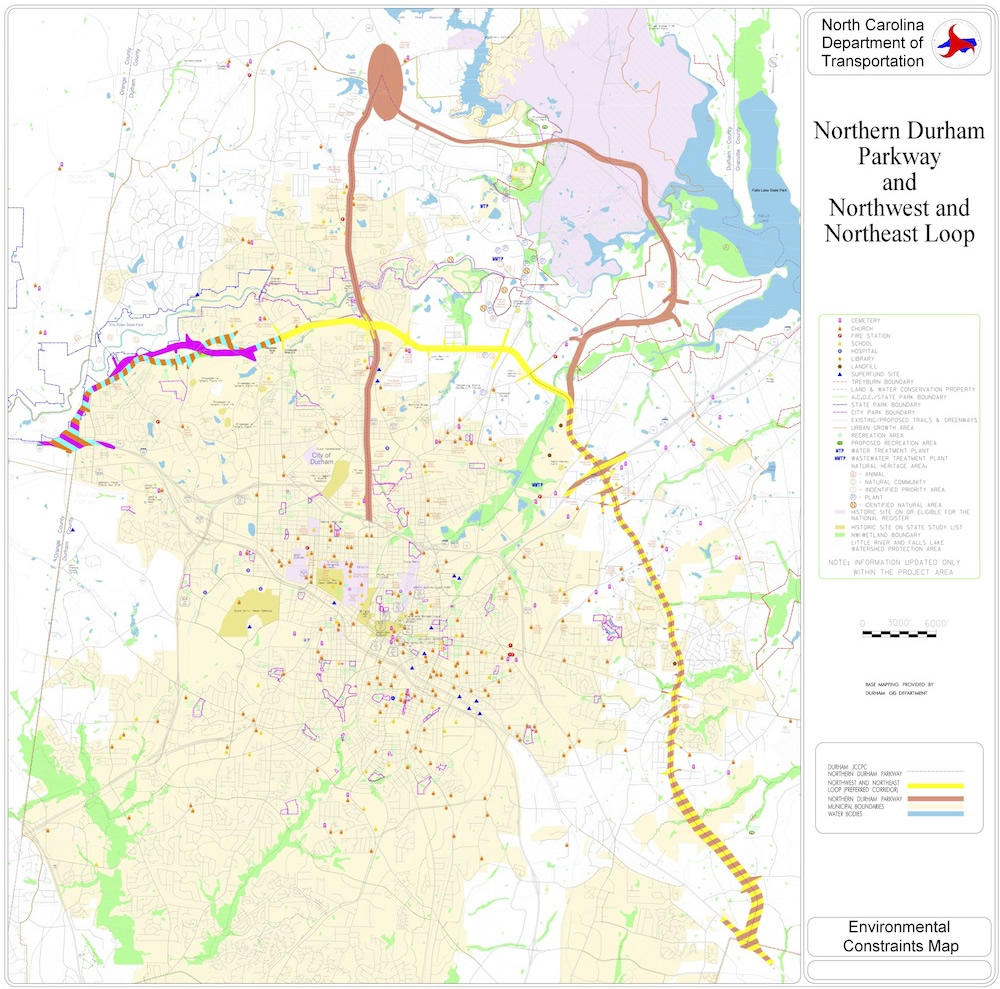
Northern Durham Parkway
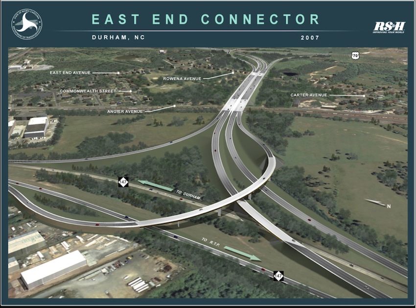
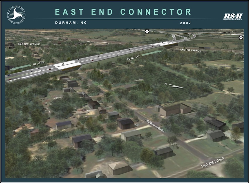
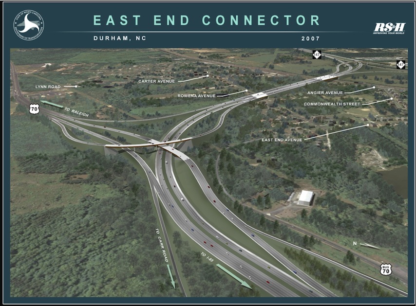
www.ncdot.gov/projects/eastendconnector/
East End Connector - Durham
"The proposed project would provide a direct connection between the Durham Freeway (NC 147) and US 70 (Miami Boulevard), as well as make improvements to US 70 from Pleasant Drive to north of Holloway Street (NC 98)."
$182 million, construction to start in 2014.

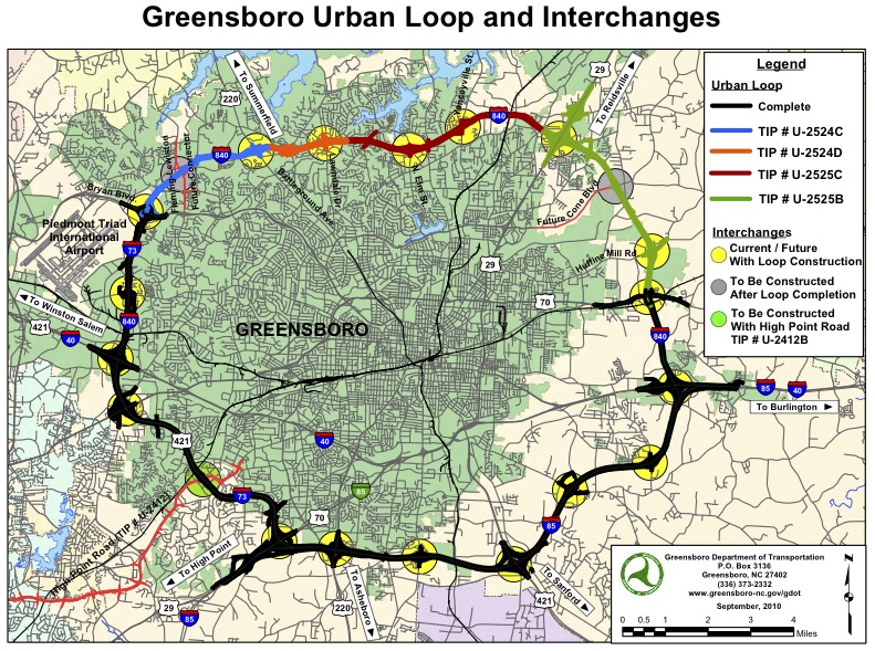
Greensboro beltway
www.ncdot.gov/projects/greensborourbanloop/
There are four projects in various stages of the construction process which will complete the remaining 15 miles of the 44-mile long loop around the city. Starting at the western end near Piedmont Triad International Airport and working eastward to US 70, the projects are:
Western Loop from north of Bryan Boulevard to US 220 (Battleground Avenue) - U-2524C
Currently acquiring right of way
Construction scheduled to begin in 2013Western Loop from US 220 (Battleground Avenue) to Lawndale Drive - U-2524D
Currently acquiring right of way
Construction scheduled to begin in 2017
Eastern Loop from US 29 north of Greensboro to Lawndale Drive - U-2525C
Right of way acquisition scheduled to begin in 2016
Construction scheduled to begin in 2019
Eastern Loop from US 70 Relocation to US 29 north of Greensboro - U-2525B
Right of way acquisition scheduled to begin in 2012
Construction scheduled to begin in 2014
There are two future projects that will add interchanges to the Greensboro Loop:
A future interchange is proposed connecting the Greensboro Loop to the proposed Fleming Road Extension that will also connect to Lewistown Road, TIP Project U-2524F.
For more information, read the Fleming-Lewistown Road Connector Feasibility Study.
A future interchange is proposed connecting the Greensboro Loop to the proposed Cone Boulevard Extension, TIP Project U-2525D. For more information, read the Cone Boulevard Extension Feasibility Study.
Western Loop from north of Bryan Boulevard to US 220 (Battleground Avenue)
Estimated Cost: Construction $101M
Property Acquisition Status:
In Progress
Construction Start:
FY 2013
Description
Construct a six-lane freeway from north of Bryan Boulevard to US 220 (Battleground Avenue).
Western Loop from US 220 (Battleground Avenue) to Lawndale Drive
Estimated Cost: Construction $88.1M
Property Acquisition Status: In Progress
Construction Start: FY 2017
Description
Construct a new six-lane freeway from US 220 (Battleground Avenue) to Lawndale Drive
Eastern Loop from US 70 Relocation to US 29 north of Greensboro
Estimated Cost: Construction $119M
Property Acquisition Start: FY 2012
Construction Start: FY 2014
Description Construct a new four-lane freeway from US 70 Relocation to US 29 north of Greensboro.
Eastern Loop from US 29 north of Greensboro to Lawndale Drive
Estimated Cost: Construction $139M
Property Acquisition Start: FY2016
Construction Start: FY 2019
Description
Construct a new six-lane freeway from US 29 north of Greensboro to Lawndale Drive.
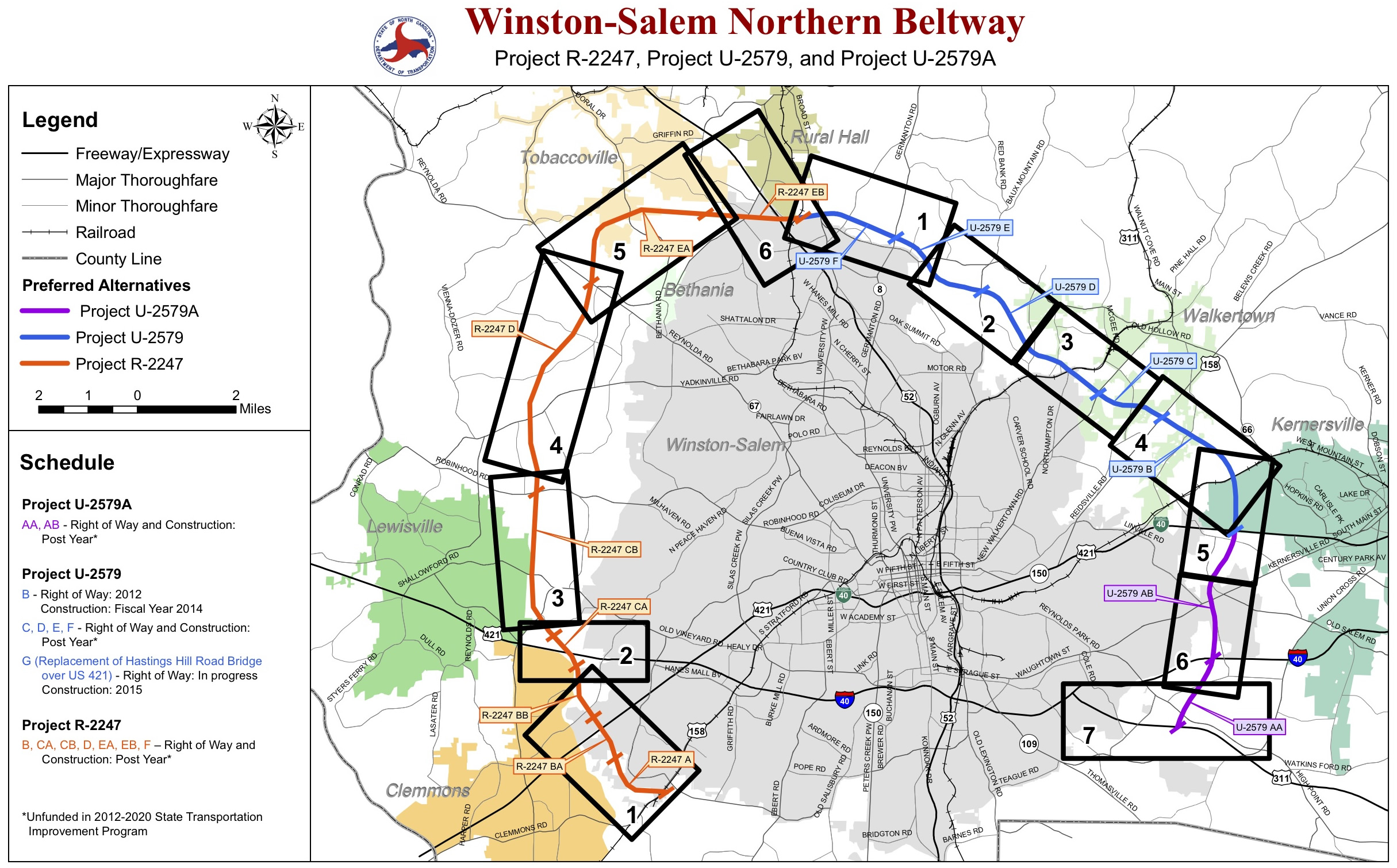
Winston Salem Northern Beltway
The project begins at U.S. 158 southwest of Winston-Salem and ends at U.S. 311 southeast of the city. The total length of the project is 34.2 miles. Environmental studies for the project are complete, and design work is currently under way.
The Beltway is made up of two sections:
The portion from U.S. 158 to U.S. 52 is known as the "western section," or State Transportation Improvement Program project R-2247; and
The section from U.S. 52 to U.S. 311 is known as the "eastern section," or STIP project U-2579. When it is complete, this section will become I-74.
Estimated Cost: $1,080 Million
Property Acquisition Start: 2012
Construction Start Date: 2015
https://apps.ncdot.gov/newsreleases/details.aspx?r=3677
JUDGE RULES IN FAVOR OF NCDOT IN WINSTON-SALEM BELTWAY LAWSUIT Thursday, May 20, 2010
1999 and 2008 cases dismissed
RALEIGH - U.S. District Court Judge Thomas D. Schroeder of the Middle District of North Carolina on Wednesday, May 19, issued his ruling in the case regarding the N.C. Department of Transportation's plans to build the Beltway in Winston-Salem. Judge Schroeder ruled in favor of NCDOT and dismissed both the 1999 and 2008 cases filed by North Carolina Alliance for Transportation Reform Inc. and Friends of Forsyth. A copy of the ruling is attached below.
Due to an injunction in the 1999 lawsuit and the subsequent 2008 lawsuit, NCDOT has been unable to move forward with buying right of way or building the Beltway. This ruling lifts the injunction and allows NCDOT staff to begin scheduling these processes.
The old schedule has been deferred because of the injunction and 2008 law
I-26 from Asheville to Tennessee state line, built in late 1990s / early 2000s. This highway was built over very steep terrain with some of the some of the biggest cuts and fills in the country.
I-26 reconstruction and realignment planned in downtown Asheville.
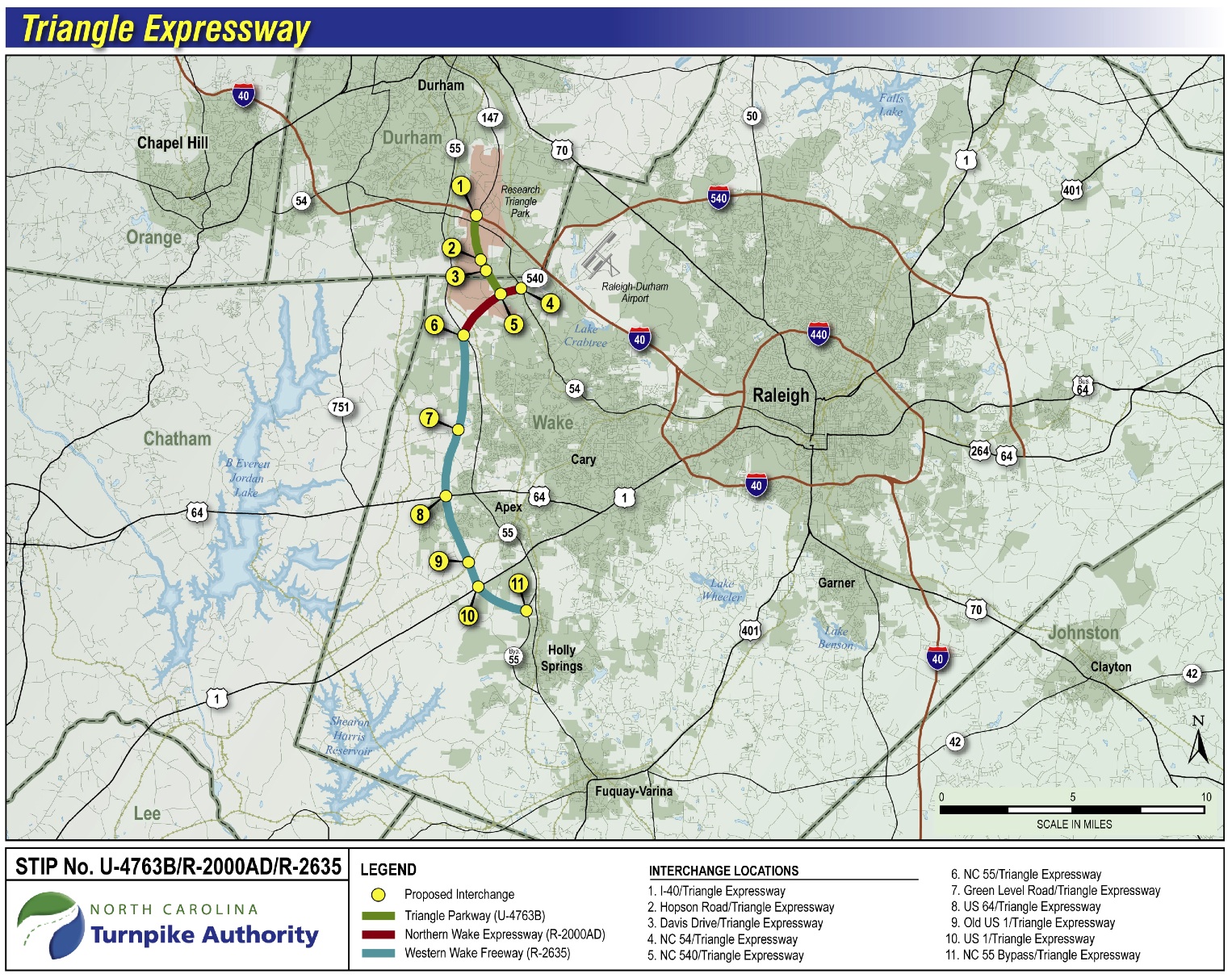
www.ncdot.gov/projects/triangleexpressway/
Triangle Expressway, a new tollroad on west side of Raleigh, now open to traffic. Cost about a billion dollars.
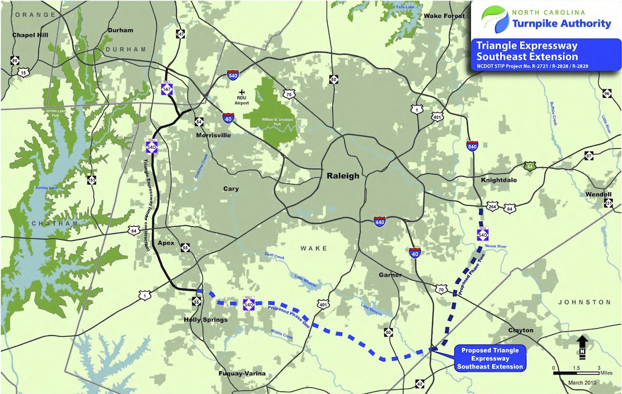
www.ncdot.gov/projects/southeastextension/
"Spanning nearly 30 miles, the proposed Southeast Extension would extend the Triangle Expressway and complete the Raleigh Outer Loop (I-540). Construction is anticipated to be completed in two phases. Phase I runs between N.C. 55 in Apex and I-40 near the Johnston County line. Phase II continues the project at I-40 and ends at the U.S. 64/U.S. 264 Bypass in Knightdale."
www.ncdot.gov/projects/gardenparkway/
"The Garden Parkway, also known as the Gaston East-West Connector, is a planned toll road approximately 21.9 miles from I-85 west of Gastonia in Gaston County to I-485 near the Charlotte-Douglas International Airport in Mecklenburg County with new crossings over the South Fork and Catawba Rivers."
"In December 2010, Alternative 9 was identified as the preferred alternative for the Garden Parkway in the project's Final Environmental Impact Statement, and was approved in the Federal Highway's Record of Decision issued on February 29, 2012. On August 28, 2012, the Southern Environmental Law Center (SELC), on behalf of Clean Air Carolina and the Catawba Riverkeeper Foundation, filed a suit in Federal District Court in Charlotte challenging the project's environmental documentation. This litigation is still pending."

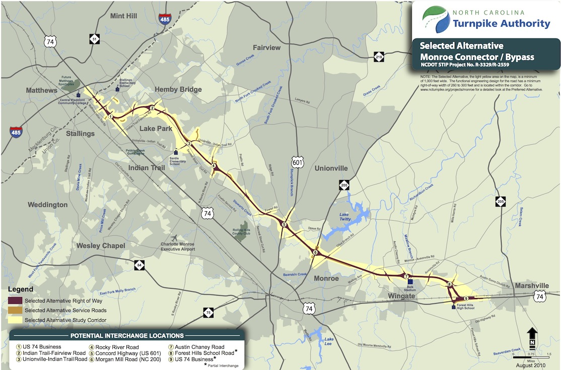
Monroe Bypass tollroad
www.ncdot.gov/projects/monroeconnector/
"The proposed project is a 19.7-mile long new location roadway from US 74 at I-485 in eastern Mecklenburg County to US 74 between the towns of Wingate and Marshville in Union County.
"Latest News and Updates
The Authority is working in close coordination with other units of NCDOT and FHWA to prepare additional documentation to respond to the Circuit Court's concerns. Documentation is expected to be complete in early 2013, with a new Record of Decision anticipated later in 2013. At that point, work on final designs and right-of-way acquisition could resume."April 30, 2013: NCDOT announced today that the U.S. Army Corps of Engineers (USACE) withdrew the project's 404 environmental permit until an updated construction timetable is established.
"NCDOT will need to reapply for this permit before construction of the road begins because it is a requirement for road projects that cross water or wetlands. NCDOT will coordinate with the USACE once the environmental study is complete and construction activities are able to resume.
"May 22, 2012: NCDOT announced today that it intends to file a petition for rehearing with the U.S. 4th Circuit Court of Appeals regarding the proposed Monroe Bypass.
"NCDOT prevailed in the initial suit filed by the Southern Environmental Law Center (SELC) challenging the environmental documents for the Monroe Bypass."
from: Smart Choices, Less Traffic: The 50 Best and Worst Transportation Projects In the United States,
Sierra Club Beyond Oil Campaign, November 2012
http://content.sierraclub.org/beyondoil/content/smart-choices-less-traffic
The proposed tolled, 20-mile multi-lane highway project parallels an existing major road near sprawling suburbs east of Charlotte, the state's largest city. Despite the road's location, it is not expected to reduce congestion on the existing road and will instead increase the amount of driving in the area. The aim of the project is to extend the road system to an area where no major arterials exist. This will likely generate suburban sprawl in largely-undeveloped parts of Union County. The project exacerbates Charlotte's existing sprawl problem, increasing auto pollution in the Charlotte metro region. This is especially devastating because the Charlotte metro area has the longest history of air quality violations in the Carolinas. The road would pave over hundreds of acres of woods and fields in the Yadkin River watershed, affecting rare and threatened aquatic species, especially mollusks. This project is expected to cost $800 million but has been postponed indefinitely after it was found that NCDOT misled the public in the project's Environmental Impact Statement.
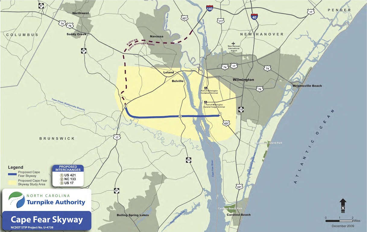
Cape Fear Skyway
www.ncdot.gov/projects/capefearskyway/
"The project, an approximately 9.5-mile proposed toll road from the U.S. 17 Bypass in Brunswick County to U.S. 421 near Wilmington, includes a new high-rise bridge over the Cape Fear River. The central purpose of the project is to improve traffic flow and freight movements by connecting major routes in Brunswick and New Hanover counties, along with providing better access to the Port of Wilmington. In addition, the project would help reduce hurricane evacuation clearance time for residents and visitors and aid in emergency evacuation form Progress Energy's Brunswick Nuclear Plant in Southport."
"Once funding is secured, the project is estimated to take five years to construct. Preliminary cost estimates for the project are between $950 million and $1.1 billion."
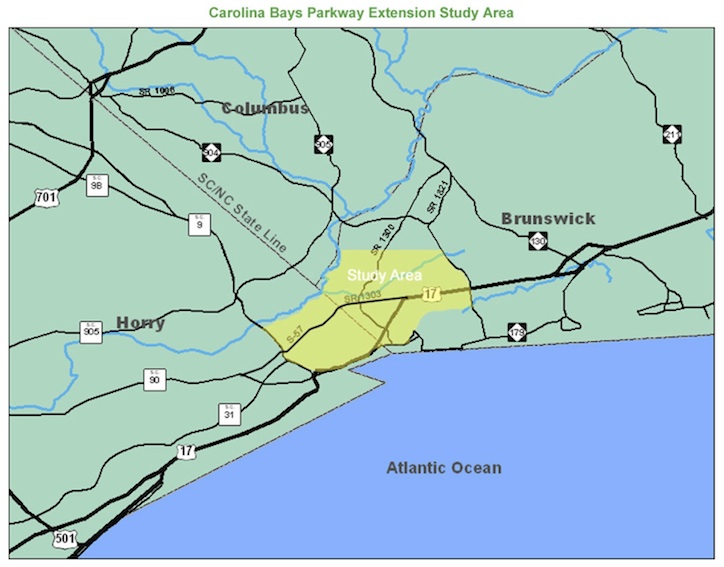
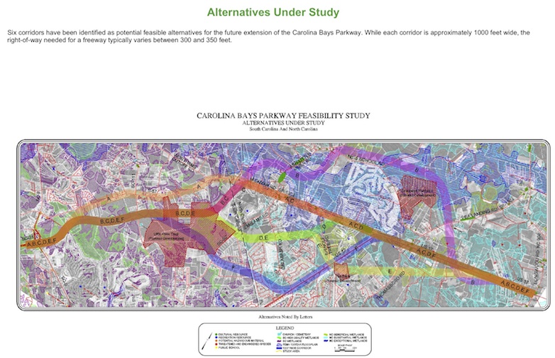
Carolina Bays Parkway Extension Feasibility Study
"The Carolina Bays Parkway (CBP) extension project involves the development of a new multilane full control of access highway facility. In South Carolina this facility will extend the CBP from SC 9 northerly approximately five miles to a logical terminus at the South Carolina / North Carolina State line. The North Carolina Department of Transportation in coordination with the South Carolina Department of Transportation (SCDOT) is concurrently developing a feasibility study to extend the multi-lane facility from the state line approximately five miles northeasternly to US 17 in Brunswick County, North Carolina.
"The development of this new controlled access facility is intended to provide a more direct and efficient movement of north-south traffic seeking to bypass congestion within the Calabash, Little River and Grand Strand areas and will be the integral part of the proposed Interstate 74 where it would extend into South Carolina from North Carolina. Development of this project will also improve traffic flow and safety at the SC-9/S-57 Intersection and provide a more direct route for coastal truck traffic moving through North Carolina."
Corridor K in western North Carolina and eastern Tennessee
www.southernenvironment.org/cases/corridor_k
www.ncdot.gov/projects/US74Relocation/
Estimated Cost: $383 million (2009-2015 STIP)
"The N.C. Department of Transportation is proposing to relocate U.S. 74 from Robbinsville to Stecoah in Graham County. This project is part of NCDOT Transportation Improvement Program Project No. A-9.
"NCDOT is currently studying the B and C portions of the project, which include constructing a four-lane, divided highway from U.S. 129 in Robbinsville to N.C. 28 in Stecoah. Section A begins in Cherokee County with a proposed terminus in Andrews and extends north into Graham County with a proposed terminus in Robbinsville. Section D has already been constructed. It begins in Stecoah and extends east into Swain County, terminating in Almond.
"According to the Draft Statewide Transportation Improvement Program, right-of-way acquisition is scheduled to begin in 2014 and construction of the B section is scheduled to begin in 2016. However, based on recent project activities, the schedule will be revised."

from: Smart Choices, Less Traffic: The 50 Best and Worst Transportation Projects In the United States,
Sierra Club Beyond Oil Campaign, November 2012
http://content.sierraclub.org/beyondoil/content/smart-choices-less-traffic
In 2008, the North Carolina Department of Transportation announced its plans to drill a 2,870-foot long tunnel almost 500 feet beneath Stecoah Gap, a saddle in the Cheoah Mountains of western North Carolina. The construction of the tunnel will occur through areas containing minerals that can release acidic runoff into rivers and streams, contributing to water pollution. This project is coupled with an expansion of a 9-mile stretch of two-lane winding highway to a four lane expressway. Corridor K is one of the 'incomplete' segments of the Appalachian Regional Commission's 1965 plan to build a highway system through the Appalachian mountain chain-- a now- outdated plan that was created when gas cost $0.31/gal. It has been rendered obsolete by the Interstate System, with I-40, I-75, 1-20, and I-16 all in the vicinity. Such an enormous construction project in such a pristine mountain range will have devastating environmental consequences. In addition the area will be negatively impacted by congestion and air pollution from increased traffic, including large trucks. The project is currently in the process of amassing funding before beginning construction.