


Kentucky
| Trillion Dollar Highway Plans = Multiple Bypass Surgery a state by state list |
|
| High Priority Corridors specified by Congress in 1991, 1995, 1998, 2005, 2012 |
|
| NAFTA Superhighways | |
| Corridors of the Future | |
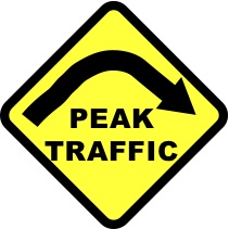
| J. Edgar Hoover Parkway: transportation surveillance, mileage taxes, RFID & video tolling |
|
| Paving Appalachia:
Corridor A to X in AL, GA, MD, MS, NC, NY, OH, PA, SC, TN, VA, WV |
|
| Alabama | Nebraska |
| Alaska | Nevada |
| Arizona | New Hampshire |
| Arkansas | New Jersey |
| California | New Mexico |
| Colorado | New York |
| Connecticut | North Carolina |
| Delaware | North Dakota |
| Florida | Ohio |
| Georgia | Oklahoma |
| Hawai'i | Oregon |
| Idaho | Pennsylvania |
| Illinois | Rhode Island |
| Indiana | South Carolina |
| Iowa | South Dakota |
| Kansas | Tennessee |
| Kentucky | Texas |
| Louisiana | Utah |
| Maine | Vermont |
| Maryland | Virginia |
| Massachusetts | Washington |
| Michigan | Washington, D.C. |
| Minnesota | West Virginia |
| Mississippi | Wisconsin |
| Missouri | Wyoming |
| Montana | |
High Priority Corridor 3: East - West Transamerica Corridor
I-66, US 460, Kentucky 80, US 400, US 54, I-40
East-West Transamerica Corridor commencing on the Atlantic Coast in the Hampton Roads area going westward across Virginia to the vicinity of Lynchburg, Virginia, continuing west to serve Roanoke and then to a West Virginia corridor centered around Beckley to Welch as part of the Coalfields Expressway described in section 1069(v), then to Williamson sharing a common corridor with the I-73/74 Corridor (referred to in item 12 of the table contained in subsection (f)), then to a Kentucky Corridor centered on the cities of Pikeville, Jenkins, Hazard, London, Somerset; then generally following the Louie B. Nunn Parkway corridor [I-66] from Somerset to Columbia, to I-65; then to Bowling Green, Hopkinsville, Benton, and Paducah, into Illinois, and into Missouri and exiting western Missouri and moving westward across southern Kansas.
government: www.interstate66.com
http://transportation.ky.gov/Planning/Pages/I-66.aspx
opponents: www.kick66.org
I-66 section in western Kentucky - from Paducah KY to Missouri, across the Mississippi River. The Green and Purple lines indicate study options. The confluence of the Ohio and Mississippi is near the proposed river crossing. Graphic from:
I-66 CORRIDOR STUDY WESTERN KENTUCKY TO MISSOURI BALLARD / MCCRACKEN COUNTY - ITEM # 1-23.00
EXECUTIVE SUMMARY OF FINDINGS AND RECOMMENDATIONS
Prepared for
Kentucky Transportation Cabinet (KYTC) – Division of Planning Kentucky Transportation Cabinet (KYTC) – District 1
Missouri Department of Transportation (MoDOT)
Prepared by
Parsons Brinckerhoff Quade & Douglas, Inc.
In Association With:
Qk4 Third Rock Consultants, LLC Cultural Resource Analysts, Inc. Fuller, Mossbarger, Scott and May Engineers, Inc.
April 2005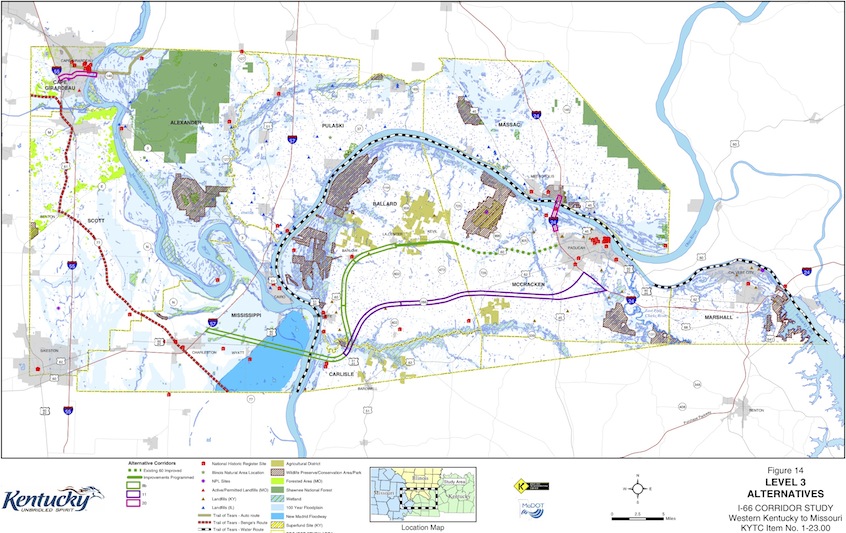
High Priority Corridor 12: United States Route 25E Corridor
United States Route 25E Corridor from Corbin, Kentucky, to Morristown, Tennessee, via Cumberland Gap, to include that portion of Route 58 in Virginia which lies within the Cumberland Gap Historical Park.
High Priority Corridor 18: NAFTA Superhighway
I-69, I-94, I-530, Routes 59, 77, 281, 82, 61, 51, Purchase Parkway, I-164, Indiana 37
Corridor from Sarnia, Ontario, Canada, through Port Huron, Michigan, southwesterly along Interstate Route 69 through Indianapolis, Indiana, through Evansville, Indiana, Memphis, Tennessee, Mississippi, Arkansas, Shreveport / Bossier Louisiana, to Houston, Texas, and to the Lower Rio Grande Valley at the border between the United States and Mexico, as follows: [I-69]
- In Michigan, the corridor shall be from Sarnia, Ontario, Canada, southwesterly along Interstate Route 94 to the Ambassador Bridge interchange in Detroit, Michigan.
- In Michigan and Illinois, the corridor shall be from Windsor, Ontario, Canada, through Detroit, Michigan, westerly along Interstate Route 94 to Chicago, Illinois.
- In Tennessee, Mississippi, Arkansas, and Louisiana, the Corridor shall--
- follow the alignment generally identified in the Corridor 18 Special Issues Study Final Report; and
- include a connection between the Corridor east of Wilmar, Arkansas, and west of Monticello, Arkansas, to Pine Bluff, Arkansas
- In the Lower Rio Grande Valley, the Corridor shall-
- include United States Route 77 from the Rio Grande River to Interstate Route 37 at Corpus Christi, Texas, and then to Victoria, Texas, via United States Route 77; [I-69 East]
- include United States Route 281 from the Rio Grande River to Interstate Route 37 and then to Victoria, Texas, via United States Route 59; [I-69 Central] and
- include the Corpus Christi North-side Highway and Rail Corridor from the existing intersection of United States Route 77 and Interstate Route 37 to United States Route 181, including FM511 from United States Route 77 to the Port of Brownsville.
- In Kentucky, the corridor shall utilize the existing Purchase Parkway from the Tennessee State line to Interstate 24.
http://transportation.ky.gov/Planning/Pages/I-69.aspx
http://www.courierpress.com/news/2011/feb/12/lobbyists-to-be-hired-for-i-69-bridge/
Lobbyists being hired to push for I-69 bridge
W. Kentucky chambers, Indiana group are paying
By Chuck Stinnett
Posted February 12, 2011
Kentucky, meanwhile, is taking steps to upgrade portions of the Pennyrile, Western Kentucky and Purchase parkways to serve as the route for I-69 through Western Kentucky.
But the missing link is a new bridge that has been proposed to be built east of Henderson.
Such a span, plus several miles of new roadway to tie into the Pennyrile Parkway south of Henderson, has been estimated to cost $1.4 billion. Officials here have accepted the likely reality that it would be a toll bridge.
"It's too expensive to fund without tolls," Jody Wassmer, president of the Greater Owensboro Chamber of Commerce, said here in 2008.
But tolls alone won't cover the cost, according to a study by the Kentucky Transportation Cabinet that calculated tolls would cover only 26 percent to 43 percent of the cost.
www.mcclatchydc.com/2013/02/03/181505/politics-and-road-building-intersect.html
Posted on Sunday, February 3, 2013
Politics and road building intersect in Kentucky
By Curtis Tate and Greg Gordon | McClatchy Newspapers
WASHINGTON — Interstate 66, once envisioned as a cross-continent highway from the Potomac to the Pacific, ends in a pile of dirt just past a cloverleaf interchange north of Somerset, Ky., the hometown of U.S. Rep. Hal Rogers.
Its completion is far from assured. But the fact that it got this far is a testament to the power of one member of Congress to get a new road through his district, even at a time when the state transportation secretary who approved it and a contractor that worked on it were under federal investigation.
http://transportation.ky.gov/program-Management/pages/2012-recommended-highway-plan.aspx
Kentucky recommended highway plan
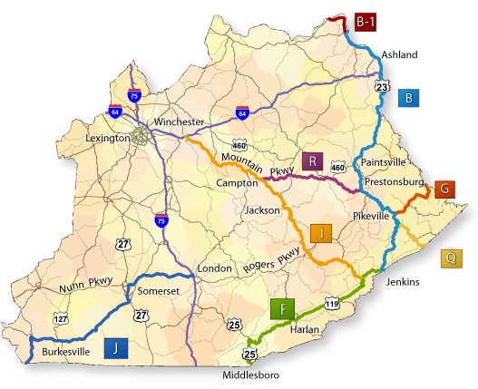
http://transportation.ky.gov/Planning/Pages/Appalachia.aspx
Corridors B, B1, F, G, I, J, Q, and R are located in total or in part in Kentucky.
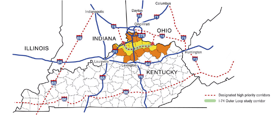
CONCEPTUAL FEASIBILITY OF
NORTHERN KENTUCKY OUTER LOOP (I-74)
FINAL REPORT
Prepared For
Kentucky Transportation Cabinet
by American Consulting Engineers
March 2003
I-265 - Outer Beltway around Louisville - new bridge to Indiana planned
I-65 - new bridge from Indiana to downtown Louisville also planned
total for the two bridges and approach roads: $2.6 billion
The Supplemental Final Environmental Impact Statement has six major parts:
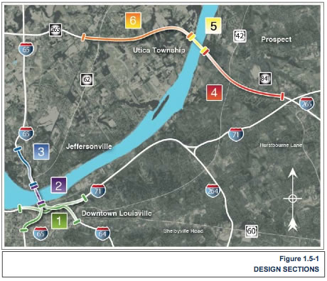 Section 1—Reconstruction of the Kennedy Interchange to the south of the existing interchange. (Also referred to as the "Kennedy Interchange Section.")
Section 2—New I-65 Northbound Bridge over the Ohio River. (Includes the reconfiguration of the existing seven-lane Kennedy Bridge to a six-lane bridge to accommodate I-65 southbound traffic.) (Also referred to as the "Downtown Bridge Section.")
Section 3—I-65 in Indiana north of the Kennedy Bridge. (Also referred to as the "Downtown Indiana Approach Section.")
Section 4—Extension of KY 841 in Kentucky from I-71 to the new Ohio River East End Bridge. (Also referred to as the "East End Kentucky Approach Section.")
Section 5—New Ohio River Bridge on the KY 841 extension. (Also referred to as the "East End Bridge Section.")
Section 6—Extension of S.R. 265 in Indiana from the S.R. 62 interchange to the new Ohio River East End Bridge. (Also referred to as the "East End Indiana Approach Section.")
government: www.kyinbridges.com
opponents: cartky.org
The Coalition for the Advancement of Regional Transportation has filed a Federal lawsuit against this project.
from: Smart Choices, Less Traffic: The 50 Best and Worst Transportation Projects In the United States,
Sierra Club Beyond Oil Campaign, November 2012
http://content.sierraclub.org/beyondoil/content/smart-choices-less-traffic
This $2.6 billion bridge over the Ohio River is a joint project of Indiana and Kentucky. It is the epitome of a classic highway boondoggle. The project calls for a bridge widening to complete Louisville's outer belt. However, the most controversial aspect of the project is the 2,000 foot 'tunnel under the trees.' A private residence in the path of the proposed bridge is a registered historic landmark. The 55-acre property was once landscaped by Fredrick Law Olmstead. Worried about sprawl and environmental deterioration, a local group petitioned for landmark status to thwart the bridge project when they first heard about it in 1988. However, the planners intend to proceed with an additional $255 million in funding for this tunnel. The federal government approved this project signaling the start of construction in early 2012.
www.nytimes.com/2013/02/19/us/like-a-river-a-bridge-project-divides-a-community.html
Like the Ohio River, a Bridge Project Divides a Community
Construction will start this summer in a $2.6 billion effort to build two new bridges between Louisville, Ky., and southern Indiana, with a completion date in 2016.
By BOBBY ALLYN
Published: February 18, 2013
http://wn.com/corridor_v_(appalachian_development_highway_system)
One of the highways that opened up eastern Kentucky is being reconstructed in Pike County. A new route for US 460 is being cut through the hills from US 23 south of Pikeville to the Virginia line near Breaks Interstate Park. It will be a four-lane highway, 16 miles long. And it will complete one of the corridors for the Appalachian Development Highway System. Governor Steve Beshear recently broke ground for the $500 million project at a ceremony in Elkhorn City. The Governor says the new road will give those who live and travel in the region something they badly need -- a modern and safer four-lane highway. Sections of the unfolding project are shown in these photos. The new road will be just a notch below interstate highway standards. It will have depressed medians, wide shoulders and partially controlled access. And in another eastern Kentucky community, a section of another new and much-improved highway has opened to traffic. Governor Beshear presided at a ceremonial opening of the new Kentucky 30 at Annville in Jackson County. The highway is being relocated as part of a long-range effort to build a new road from Interstate 75 at London to the Mountain Parkway in Wolfe County.
published: 27 Jan 2011