


Tennessee
| Trillion Dollar Highway Plans = Multiple Bypass Surgery a state by state list |
|
| High Priority Corridors specified by Congress in 1991, 1995, 1998, 2005, 2012 |
|
| NAFTA Superhighways | |
| Corridors of the Future | |
| J. Edgar Hoover Parkway: transportation surveillance, mileage taxes, RFID & video tolling |
|
| Paving Appalachia:
Corridor A to X in AL, GA, MD, MS, NC, NY, OH, PA, SC, TN, VA, WV |
|
| Alabama | Nebraska |
| Alaska | Nevada |
| Arizona | New Hampshire |
| Arkansas | New Jersey |
| California | New Mexico |
| Colorado | New York |
| Connecticut | North Carolina |
| Delaware | North Dakota |
| Florida | Ohio |
| Georgia | Oklahoma |
| Hawai'i | Oregon |
| Idaho | Pennsylvania |
| Illinois | Rhode Island |
| Indiana | South Carolina |
| Iowa | South Dakota |
| Kansas | Tennessee |
| Kentucky | Texas |
| Louisiana | Utah |
| Maine | Vermont |
| Maryland | Virginia |
| Massachusetts | Washington |
| Michigan | Washington, D.C. |
| Minnesota | West Virginia |
| Mississippi | Wisconsin |
| Missouri | Wyoming |
| Montana | |
High Priority Corridor 7: East-West Corridor
Route 72, I-565, Georgia 20, Route 411 to I-75
Memphis, Huntsville, Atlanta, Chattanooga
part of this is on Appalachian Corridor V
High Priority Corridor 8: Highway 412 East-West Corridor
Highway 412 East-West Corridor from Tulsa, Oklahoma, through Arkansas along United States Route 62/63/65 to Nashville, Tennessee.
High Priority Corridor 11: Appalachian Regional Corridor V
Batesville, MS to Chattanooga, TN: SR 6, SR 24, I-565, US 72
High Priority Corridor 12: United States Route 25E Corridor
United States Route 25E Corridor from Corbin, Kentucky, to Morristown, Tennessee, via Cumberland Gap, to include that portion of Route 58 in Virginia which lies within the Cumberland Gap Historical Park.
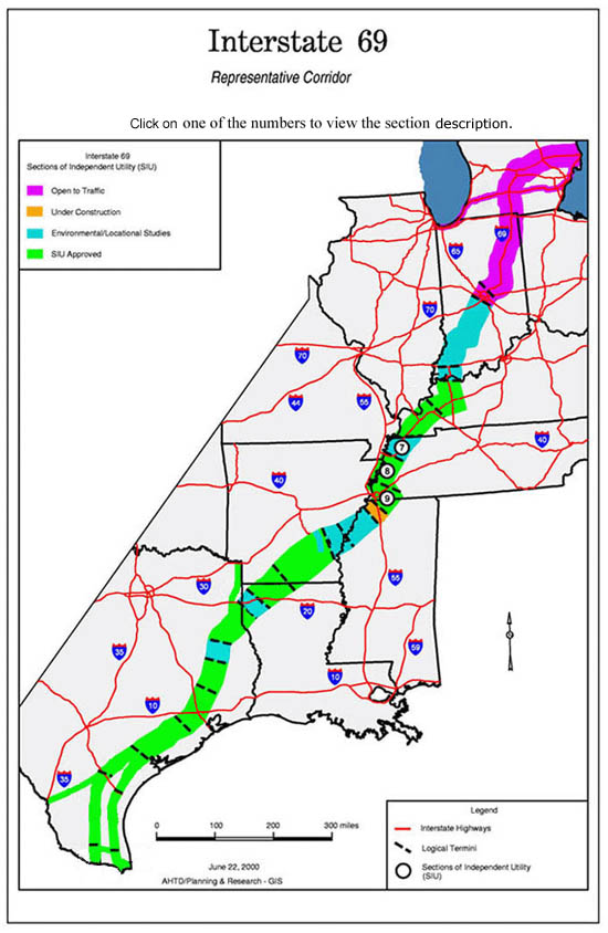
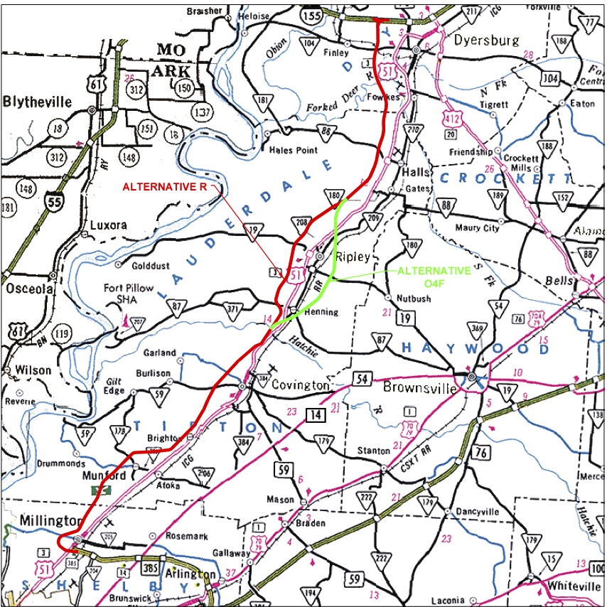
High Priority Corridor 18: NAFTA Superhighway
I-69, I-94, I-530, Routes 59, 77, 281, 82, 61, 51, Purchase Parkway, I-164, Indiana 37
Corridor from Sarnia, Ontario, Canada, through Port Huron, Michigan, southwesterly along Interstate Route 69 through Indianapolis, Indiana, through Evansville, Indiana, Memphis, Tennessee, Mississippi, Arkansas, Shreveport / Bossier Louisiana, to Houston, Texas, and to the Lower Rio Grande Valley at the border between the United States and Mexico, as follows: [I-69]
- In Michigan, the corridor shall be from Sarnia, Ontario, Canada, southwesterly along Interstate Route 94 to the Ambassador Bridge interchange in Detroit, Michigan.
- In Michigan and Illinois, the corridor shall be from Windsor, Ontario, Canada, through Detroit, Michigan, westerly along Interstate Route 94 to Chicago, Illinois.
- In Tennessee, Mississippi, Arkansas, and Louisiana, the Corridor shall--
- follow the alignment generally identified in the Corridor 18 Special Issues Study Final Report; and
- include a connection between the Corridor east of Wilmar, Arkansas, and west of Monticello, Arkansas, to Pine Bluff, Arkansas
- In the Lower Rio Grande Valley, the Corridor shall-
- include United States Route 77 from the Rio Grande River to Interstate Route 37 at Corpus Christi, Texas, and then to Victoria, Texas, via United States Route 77; [I-69 East]
- include United States Route 281 from the Rio Grande River to Interstate Route 37 and then to Victoria, Texas, via United States Route 59; [I-69 Central] and
- include the Corpus Christi North-side Highway and Rail Corridor from the existing intersection of United States Route 77 and Interstate Route 37 to United States Route 181, including FM511 from United States Route 77 to the Port of Brownsville.
- In Kentucky, the corridor shall utilize the existing Purchase Parkway from the Tennessee State line to Interstate 24.
this map of I-69 from Tenn DOT is out of date. I-69 in southwest Indiana is under construction. A segment in Mississippi is open. A few segments in Texas are open. Studies are underway on most of the rest of the route.
High Priority Corridor 42: A portion of Corridor V of the Appalachian Development Highway System
The portion of Corridor V [US 278 / MS 6] of the Appalachian development highway system from Interstate Route 55 near Batesville, Mississippi, to the intersection with Corridor X [US 78] of the Appalachian development highway system near Fulton, Mississippi.
Restates the priorities in Corridors 10 and 11.
High Priority Corridor 45: United States Route 78 Corridor and Corridor X of the Appalachian Development Highway System
The United States Route 78 Corridor from Memphis, Tennessee, to Corridor X of the Appalachian Development Highway System near Fulton, Mississippi, and Corridor X of the Appalachian Development Highway System extending from near Fulton, Mississippi, to near Birmingham, Alabama. [I-22] [seems to be a duplicate of Corridor 10]
Memphis
I-40 through Overton Park (stopped in famous Section 4(f) lawsuit upheld by U.S. Supreme Court in 1971)
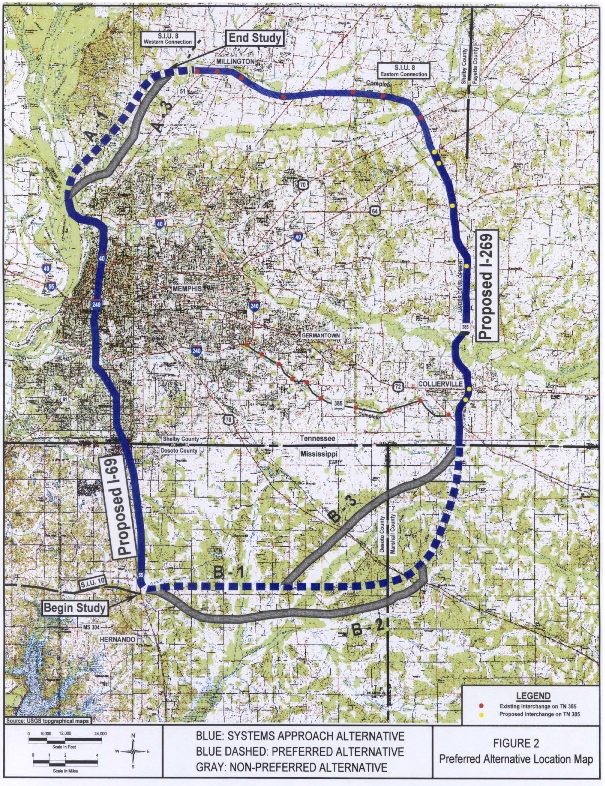
I-269 - Outer Beltway around Memphis - partly built, part under construction. 269 is about half completed although I-40 through central Memphis was never finished. The "Overton Park" lawsuit went all the way to the Supreme Court, which upheld the "Section 4(f)" law of 1966 (which prohibits federal transportation projects in parks unless there is not a "prudent and feasible" alternative).
from: Smart Choices, Less Traffic: The 50 Best and Worst Transportation Projects In the United States, Sierra Club Beyond Oil Campaign, November 2012
http://content.sierraclub.org/beyondoil/content/smart-choices-less-trafficInterstate 269 is a 60-mile outer beltway around Memphis, 15 to 20 miles beyond the inner beltway, I-240. The route, mostly through farmland, wetlands, and open spaces, is part of the I-69 "NAFTA Highway" system that was designed to reduce congestion on the inner beltway. But truckers believe that the highway, which was first proposed in the early 2000s when gas was around $2.00 per gallon, will add 40-plus miles to their trips. Initial proposals for the project were opposed by the citizens and mayors of Memphis and Shelby County, citing "nothing but problems for Memphis." They feared the project would induce sprawl and deepen economic segregation in the region. Another objection is that it is mainly a real estate development scheme, designed to spur the growth of suburbs that will waste tax dollars for the benefit of developers. The regional Memphis Planning Organization is planning more six to eight lane suburban roadways, continuing the trend of auto-dependence in Memphis. This project and the Planning Organization's "Vision Study" may encourage exurban officials to think ahead about what type of development they want, but the impacts of these highway projects on Memphis and the larger region must be part of the future conversation.
Kirby Parkway - Shelby Farms Parkway
www.tdot.state.tn.us/kirbyparkway/default.shtml
The city of Memphis, in conjunction with the Federal Highway Administration (FHWA) and the Tennessee Department of Transportation (TDOT), is proposing to construct the 2.5-mile Kirby Parkway from Walnut Grove Road to the intersection of Whitten and Macon Roads in Memphis, Shelby County, Tennessee. The new road design consists of a four-lane, median-divided, access-controlled parkway.
opposition: http://shelbyfarmsparkway.wordpress.com
www.tdot.state.tn.us/kirbyparkway/faq.shtml
"The project continues east along Walnut Grove Road, but does not impact any of the contributing recreational resources inside Shelby Farms Park."
Reply: Section 4(f) applies whether a park has recreational facilities or merely nature preservation. Swing sets, baseball fields, hiking trails and protected natural areas are all subject to 4(f) protection.
www.peaktraffic.org/4f.html
57 decibels is the standard required for "tracts of land in which serenity and quiet are of extraordinary significance and preservation of those qualities in essential if the area is to continue its intended purpose."
23 CFR Ch.1 (4-1-95 Edition) 771.135(p)(4)(i) states that a "constructive use" of parkland occurs if "the projected noise level increase attributable to a project substantially interferes with the use and enjoyment of a noise-sensitive facility of a resource protected by section 4(f) ... [such as] enjoyment of an urban park where serenity and quiet are significant attributes."
I-22 from Memphis to Birmingham is mostly done, the eastern terminus in Birmingham is still not completed.
(brand new interstate)
Nashville
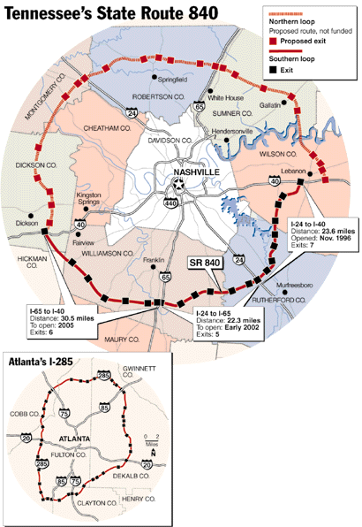
Route 840 - south side is done (giant Outer Beltway). North side has yet to be built.
TDOT Celebrates Grand Opening Of State Route 840 On November 2
THURSDAY, OCTOBER 25, 2012 | 03:05 PM
Nashville, Tenn. – October 25, 2012- Tennessee Gov. Bill Haslam and Tennessee Department of Transportation (TDOT) Commissioner John Schroer announced today that the final leg of SR 840 will be fully open to vehicles beginning at 6:00 p.m. on Friday, November 2, 2012.The official opening will follow a completion celebration scheduled to take place on November 2, from 11:00 a.m. - 2:00 p.m. The event will be held on the newly completed section of SR 840 near the Carter's Creek Pike interchange in Williamson County.
SR 840 connects Wilson, Rutherford, Williamson, Hickman, and Dickson counties and provides access to Interstate 40 both east and west of Nashville, Interstate 65, and Interstate 24. The planning and construction of the scenic 78-mile route has been an active TDOT project for over 26 years.
www.isdn.net/840a/group.html
840 Alternatives is a citizens advisory group which seeks to educate Middle Tennesseans about the dangers of -- and positive alternatives to -- the proposed construction of State Route 840 North through Wilson, Sumner, Robertson, Cheatham, and Dickson Counties.www.tennessean.com/local/columnists/chavez/archives/01/11/10365754.shtml
State spends a lot of money on scenic roads that travel through nowhere - November 8, 2001
Eastern Tennessee
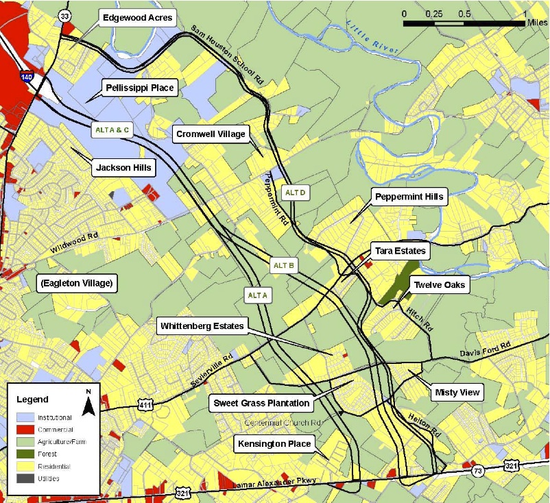
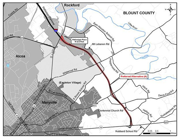
Pellissippi Parkway Extension (I-140)
State Route 162 (Pellissippi Parkway Extension)
From SR 33 to SR 73 (US 321) in Blount County.www.tdot.state.tn.us/pellissippi/
After consideration of input from the public, local officials and local, state and federal agencies, as well as weighing of the impacts of the project alternatives on the human and natural environment, TDOT has selected Alternative A (see Figure below) as its Preferred Alternative for the proposed project.
active opposition since 2002 - see www.saveitdontpaveit.org
CAPPE -- Citizens Against the Pellissippi Parkway Extension, Inc.
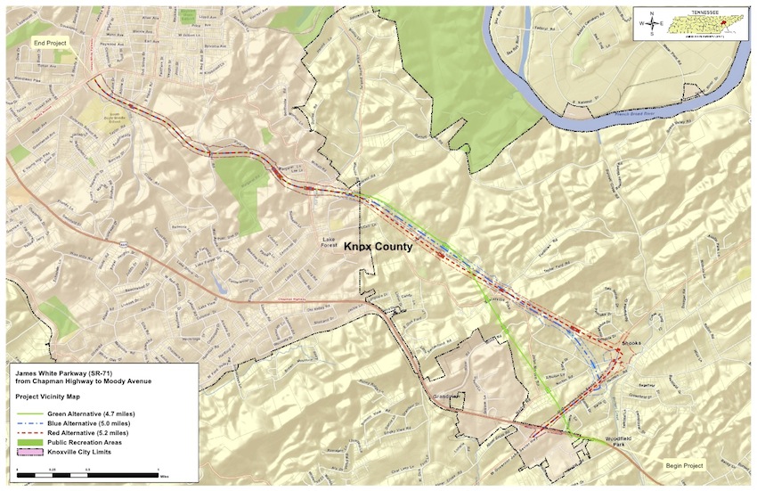
James White Parkway Extension
active opposition for years; TDOT held a public hearing on this last month (2012)
www.tdot.state.tn.us/sr71/default.shtml
James White Parkway - (State Route 71) Knox County
From Chapman Highway (State Route 71) to Moody Avenue in Knoxville.
Project Description
The Tennessee Department of Transportation (TDOT), in accordance with the Federal Highway Administration (FHWA), is preparing an Environmental Impact Statement (EIS) for the proposed construction of James White Parkway from Chapman Highway (U.S. 441/ SR-71, hereafter referred to as Chapman Highway) to Moody Avenue in South Knoxville, Knox County, Tennessee. The proposed project would extend the existing James White Parkway, which currently ends at Moody Avenue, southward to Chapman Highway (SR-71) near its intersection with Governor John Sevier Highway (SR-168). ...A Final EIS (FEIS) was approved for the South Knoxville Boulevard (James White Parkway) project on June 24, 1977. That FEIS covered a project which began at Chapman Highway near Longvale Drive and extended northward to SR-158 (CBD Loop) in Knoxville. Since that time, the segment of that project from the CBD Loop southward to Moody Avenue has been constructed and opened to traffic. This roadway is known as the James White Parkway. The segment of the approved project alignment between Old Sevierville Pike and Chapman Highway was subsequently determined to have engineering constraints due to several sinkholes along the route. The approved alignment also required a shift near Redbud Drive to avoid a historic church and residences.
Relocated Alcoa Highway
proposed 8-lane limited access highway paralleling US 129 in Blount County
I-3 Georgia to Knoxville, TN (see Georgia entry)
Update on I-3 from WaysSouth
I-3 is a new interstate highway proposed to connect Oak Ridge to Savannah, Georgia. One proposed route uses I-140 to US-129 north of the airport and continues across the Southern edge of the Great Smoky Mountains National Park and across the Cherokee and Nantahala National Forests. This massive project would cut through and disrupt some of the Southeast's most prized natural and wild areas.
A corridor study of I-3 by Wilbur Smith Associates is underway. The study area extends south to north from Savannah to Augusta, on to Lavonia, Georgia, and then to Knoxville; the study area extends from Atlanta on the west to Columbia and Greenville, South Carolina, in the east.
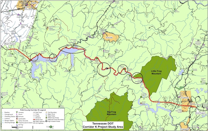
Corridor K in western North Carolina and eastern Tennessee
www.tdot.state.tn.us/corridork/